I have recently published a report with Border Forensics titled Mission Accomplished? The Deadly Effects of Border Control in Niger. This investigation provides an in-depth analysis of the severe implications of Law 2015-36 on illegal trafficking of migrants in Niger, adopted in May 2015. The report scrutinizes the increased dangers faced by migrants due to heightened border controls and the changing dynamics of cross-Saharan travel. It employs innovative geo-spatial analysis and remote sensing methodologies to uncover the correlation between increased border control and the dispersal of migrants’ trajectories, leading to life-threatening conditions in the desert. The report also challenges the mission accomplished narrative of the Nigerien government and its international partners, revealing a humanitarian crisis exacerbated by these policies.
In May 2015, the government of Niger, backed by the European Union, its members, and affiliated bodies, implemented Law 2015-36 aimed at curtailing illegal migrant trafficking, ostensibly to shield migrants from exploitative traffickers. This law rendered services like transportation and lodging for migrants, which were once tacitly approved by Niger’s government and crucial for both local economies and trans-Saharan travel, illegal and punishable by severe sanctions, including imprisonment. Contrary to the claims of success touted by the Nigerien authorities, their global partners, and media, these stringent measures and the subsequent intensification of border controls have neither discouraged migrants from using Niger’s routes nor safeguarded them from predatory traffickers. Reports from academia, journalism, and human rights organizations indicate that these punitive policies and control tactics have necessitated a clandestine transport economy, thereby heightening the perils migrants now face. To avoid detection, carriers are now choosing more secluded and dangerous paths, leading to perilous and sometimes deadly circumstances for migrants, especially when vehicles malfunction or are abandoned in fear of arrest.
Since this law’s enactment, organizations like Alarm Phone Sahara (APS) have been relentlessly highlighting the resulting migrant humanitarian crisis. The actual number of fatalities in the Nigerien desert remains uncertain, with the Missing Migrant Project recording at least 1,092 deaths since 2014. These numbers, however, barely scratch the surface, as the strict penalties enforced by Law 2015-36 have pushed trans-Saharan migrations into more isolated areas, making data collection on deaths even more challenging. In response, Border Forensics has developed cutting-edge geospatial and remote sensing techniques to empirically document the lethal impacts of Niger’s border control practices.
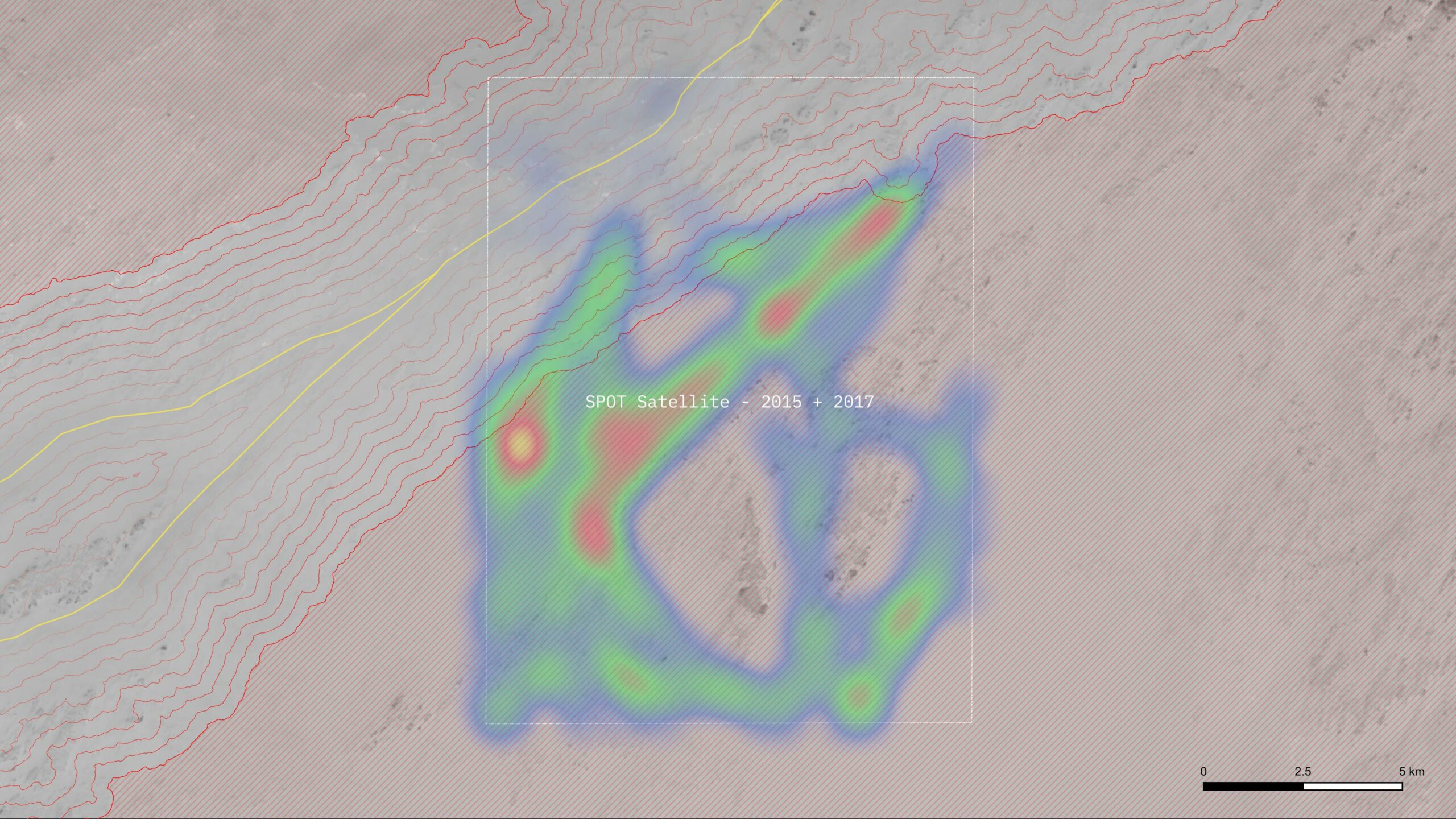
These techniques were applied at three key locations along the Dirkou-Sabha route: Séguédine city, Madama military fort, and the Toummo border post near the Niger-Libya boundary. The focus was on assessing water scarcity and migrant detection by security forces. The methods, akin to those used in the Sonora Desert at the US-Mexico border, include a viewshed analysis to gauge track visibility from main roads and a cost-distance analysis to calculate the minimum water required for distressed individuals to reach assistance, considering climate and terrain data.
The application of these methods to the selected sites revealed distinct patterns at each location. The analysis showed a notable increase in military and security activities post the implementation of Law 2015-36. The criminalization of migration (and aiding migrants) under this law has led to the proliferation of checkpoints and military fortifications, compelling transporters and migrants to divert to less visible and more hazardous paths, thus elevating the risk of vehicle breakdowns, abandonment, and dehydration.
Border Forensics quantified the dehydration risk associated with these new routes. Their studies confirmed a direct link between enhanced border control and reduced route visibility. These controls have driven transporters and migrants to less detectable paths, far from main roads or help, mirroring the situation at the Mexico-US border. The analysis indicated a strong correlation between less visible routes and increased dehydration and death risks. The findings demonstrate that efforts to avoid detection significantly escalate water loss, highlighting the direct relationship between route invisibility and danger levels. This trend points to increased difficulties in accessing main routes and aid, raising the likelihood of cognitive issues, dehydration, and heatstroke among migrants. The analysis starkly illustrates how even minor deviations from main routes substantially amplify the risks of dehydration and fatality.


